The following blog is a collaboration between Bruce Holmes, my husband, and me, Connie Waetzig Holmes. The piece is written from his perspective.
Long, long ago…
Ten years ago to be precise, the ICON Aircraft Company’s founders, Kirk Hawkins and Steen Strand, had a dream to create an aircraft to stimulate new consumers of the experience of flight, or unbounded liberty in the air as I like to describe it, reaching consumers outside of the traditional markets for light aircraft, for example from the power sports communities. Their design had to have capabilities and style that would be innovative, safe, and fun to fly, landing on both land water (“Bad Ass” as the company likes to describe it). The result: The amazing Icon A5 went into design and production.
Full throttle ahead to delivery in 2018: I and my wife Connie now own one of these awesome amphibians. I took delivery at the ICON plant in Vacaville, CA, on November 19. The next day began the epic journey home to Virginia. Why the ICON for me? More on that question later.
Flying from coast to coast in any airplane is a great means of getting to know your machine, intimately – even more so if the aircraft is slow. The A5 has a maximum airspeed of 109 mph or 176 kph. What it lacks in speed, it makes up in maneuverability and efficiency.
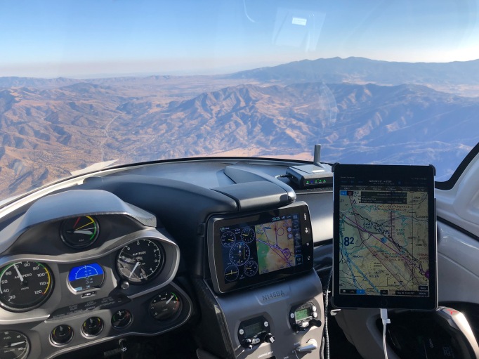
Delivery and Keys at the ICON Aircraft Company Plant at Nut Tree Airport (KVCB) in Vacaville, CA.
Oh Happy Day!
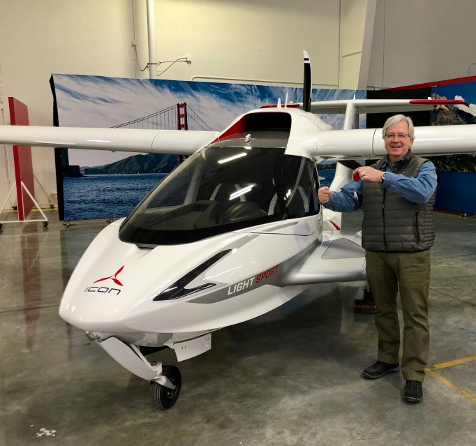
Passing of the Keys and the Delivery Inspection for My New A5.
Flight Day 1: Takeoff from Vacaville, CA. to Fuel Stop in Bakersfield, CA.
The beginning of the journey: takeoff from Runway 2 at Nut Tree Airport (KVCB), Vacaville, CA. On the morning of departure, I called Flight Service, gave my flight plan for the route down the San Joaquin Valley toward the Tehachapi Pass. The briefer said, “VFR Not Recommended …” and “… expect IFR conditions all day, all the way to the southern end of the Valley.” His caution was proper and was due to the smoke from the California wild fires, still burning north of us and farther south near LA. Because of clear sky overhead at Vacaville, I decided I could take a safe look; I could always come back and re-plan if needed. The briefer was accurate (about the smoke) but also inaccurate (about the ceilings and visibility). Actually, the ceiling was unlimited, and the visibility was more than 6 or 10 miles all the way to Shafter-Minter Field (KMIT), a crop duster airport near Bakersfield at the southern end of the San Joaquin Valley.
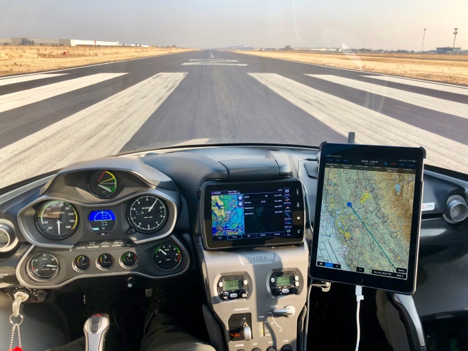
Runway 02 at Nut Tree Airport (KVCB) the Beginning of the 2,613 st.m. Journey to Virginia. (Bruce Holmes)
The Plan
The final trip itinerary did not actually emerge until about Day 3, but here is the routing that I ended up taking. As a means of managing total situational awareness for the mission, I enlisted the help of a long-time friend, fellow aviator, and business colleague, Robert Wright (Wright Aviation Solutions). He and I organized the idea of a “virtual copilot” operation. We would hold daily briefings on the usual matters of wind, weather, and fuel planning. We also discussed a range of ancillary issues such as lodging options, crew-car availability, fuel price, sunrise/sunset, density altitude considerations in runway choice, etc. Many of these topics were much easier for my “co-pilot” to investigate ahead of real-time changes necessitated by unpredicted winds or weather, all making for a higher level of confidence and comfort along the way.
We also discussed, but did not execute, sight-seeing side excursions from the route plan (e.g., Grand Canyon). My single-minded mission was to bring the airplane home. The splash-ins sight-seeing can wait for future flights. As you will see, this trip had plenty of eye-candy along the say.
We used satellite tracking and text messaging tools during the day for double checking each of the flight segments as they unfolded. We can imagine that prospective ICON flyers using the A5 for multi-day adventure flying and visiting America’s waterways might have enhanced fun with an “adventure concierge” support mechanism such as we employed.
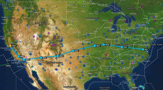
The Route Plan: Vacaville, CA – Bakersfield, CA – Victorville, CA – Flagstaff, AZ – Santa Fe, NM – Liberal, KS – Clinton, MO – St. Louis, MO – Lexington, KY – Chesterfield, VA – Williamsburg, VA. (Bruce Holmes)
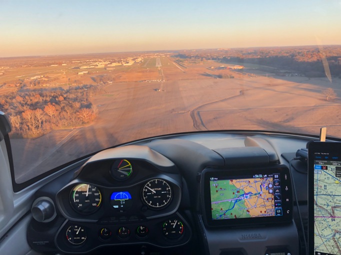
The ICON has a cosmic viewing portal (AKA windshield) to the world. I can imagine how the astronauts on the International Space Station felt when they got their new panoramic viewing window a few years back. Airliner windows are way too small; in fact, if they would fix up a viewing bubble with seating on top of the fuselage, I’ll bet they could find a new way to generate revenue. The sun was in my face for the three hours of flight down the Valley, but my vision was saved by the sun film.
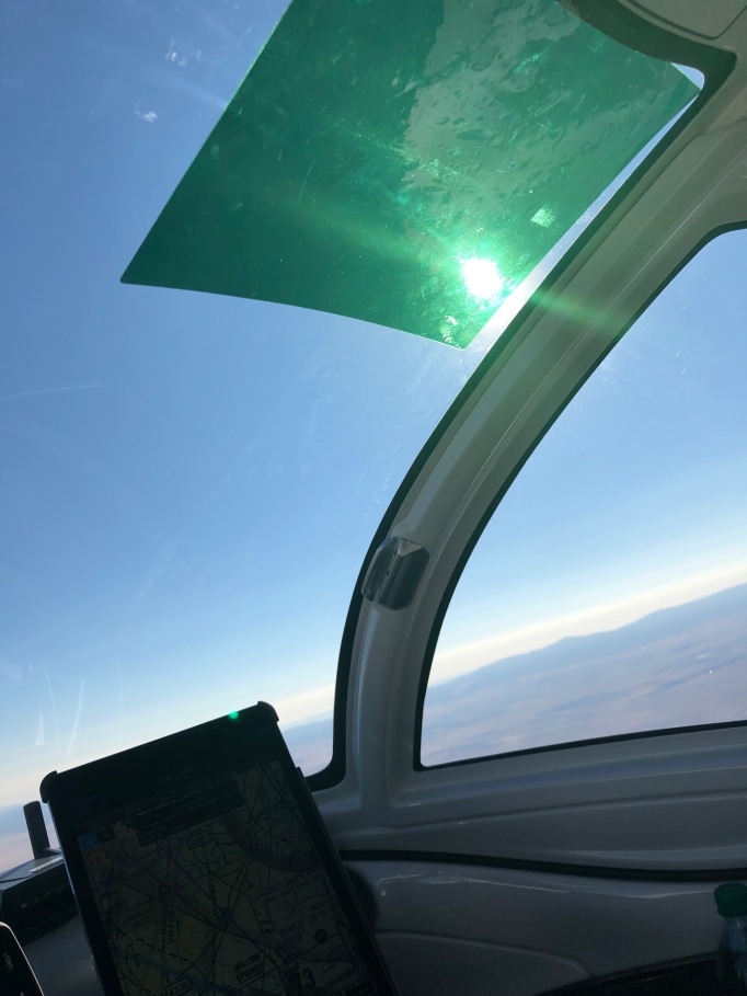
Simple and Low-Cost Sunscreen. (Bruce Holmes)
Smoke over the San Joaquin Valley from the Wildfires in California. (Bruce Holmes)
When I arrived at KMIT, the crop duster pilots were on lunch break and came up to the ICON exclaiming, “Wow, what IS that!?” They would take pictures of each other with the aircraft, while I took pictures of them taking pictures. This was the first of a performance that was repeated everywhere I stopped on the journey home to Virginia. After selling me some fuel, they asked if I’d had lunch and treated me to some of their box lunch offerings. Below are pictures of my plane and two of the agricultural aircraft.


Navigating through the Tehachapi Pass into the Mojave Desert.
After eating a bite and filing the flight plan for the next leg, I took off headed toward the Tehachapi Pass, the entrance to the southwestern desert.
CA Route 58 Snaking Along the Tehachapi Pass from Bakersfield into the Mojave Desert. (Bruce Holmes)
Spread below me in the Mojave Desert are Edwards AFB and NASA Armstrong Flight Research Center. These venues are where the future of aviation is unfolding with electric propulsion system research, supersonic boom flight testing to re-open the supersonic transport era, and the opening of space tourism with the recent successful flight of Richard Branson’s Virgin Spaceship Unity. It blasted to 51.4 miles above the earth and landed on the runway you see in the distance in the photo. The spaceship/aircraft was created by colleague Burt Rutan and his The Spaceship Company. (Gotta love their address: Mojave, California, Earth.)
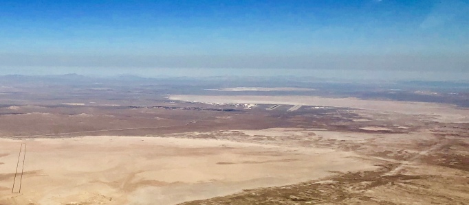
Edwards AFB, NASA Armstrong Flight Research Center and the Mojave Air and Space Port in the Distance. (Bruce Holmes)
Next, I landed in Victorville, CA, at Southern California Logistics Airport (KVCV), kind of a “spook” airport. (Lots of aircraft festooned with lots of antennae and painted gray.) I parked at Millionaire FBO. Ramp crew showed up — wanted pictures of themselves with the ICON. I think I held the record, at least that day, for the smallest aircraft on the field. I took advantage of their waived parking fee for topping off my fuel load. I imagine they were not thinking about an ICON showing up, needing only five gallons of fuel. I picked up the keys to their crew car and headed to my hotel for the night.
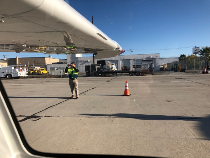
Millionaire FBO Ramp Crew Member at Victorville (KVCV) Taking Pictures of Himself with the ICON. (Bruce Holmes)
Flight Day 2: From Victorville, CA, Across the Desert Toward the Next Fuel Stop in Flagstaff, AZ, then on to Santa Fe, NM.
I was up at dawn, dropped the crew car back at Millionaire. In my adrenaline-fueled excitement taking delivery on Monday, I flew away on Tuesday from Vacaville with the keys to my rental car. Before I departed the FBO in Victorville, I left the keys with the person at the desk, who kindly assured me the keys would be shipped back to the rental car company on my behalf. Lesson: Take a deep breath every now and then and ask, “Self, what have I missed?”
The ICON A5 and I were then eager to continue the journey. I departed eastward from Victorville — into pure, beautiful, desolate desert. Over the miles, the hazy terrain gave way to unlimited views of desert and the distant horizon.


Looking north over Bullhead City, AZ, on the eastern side of the Colorado River and Laughlin, NV, on the western side, I saw green terrain. These two cities are known for their casinos, outdoor activities, and various sorts of nighttime entertainment. Tempting, but not on my flight plan. Bullhead City Airport (KIFP) has a runway long enough to handle private jets and the Sun West charter flights reserved through Harrah’s for “high-end gamblers.” A Sun West Boeing 737 climbing out in the distance in front of me was one of the small handful of other aircraft I saw during the entire trip. Needles, CA, is off to my right to the south. These were the last fuel stop options for almost two hours to Flagstaff, AZ, ahead. In the eastern U.S. from 10,000 feet, AGL, fuel stops are within gliding distance in many places.
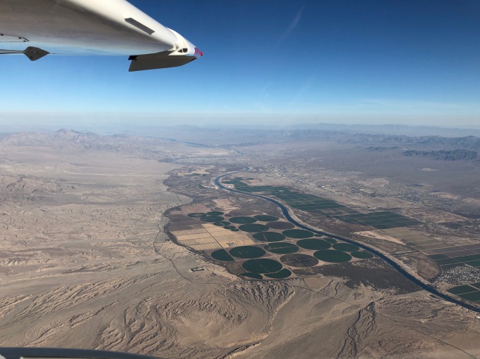
The Colorado River Dividing Bullhead City, AZ, and Laughlin, NV. (Bruce Holmes)
I arrived at Flagstaff, AZ, Pulliam Field (KFLG), for fuel and lunch. The field elevation is 7,015 ft. MSL with a runway length of 8,800 feet. Even the ICON would need about half of the runway on a hot day because of density altitude. Here, I saw the second aircraft in my airspace so far, a SkyWest regional jet headed to Phoenix. As was the case for more than 90-percent of the journey, my awareness of other traffic was mostly from interactions with air traffic controllers helping the big guys at the flight levels find smoother rides. This brings up a point: I experienced virtually no turbulence for most of the trip. I thought about giving advice over the air, but settled for automated Pilot Reporting (PIREPS) through the apps on the iPad.

Mesmerizing Canyon-land and Desert Scenery from Flagstaff, NM to Santa Fe, NM.
The view from just above the landscape of mesas, canyons, gorges, and desert looks like being on another planet. Here are samples from the flight leg between Flagstaff and Santa Fe. A thought that recurred was, “I wonder what this all looked like a couple of millennia ago?”


Here are more samples of the captivating view getting closer to Santa Fe. Except for the industrial site on the mesa in the lower left-hand image below, there were few signs of human activity for much of this part of the journey.


I touched down at the Santa Fe Airport (KSAF) and parked at their Signature Flight Support FBO for the night. The next day would be one of the longest of the trip, so I found a hotel not far from the airport, called Uber, and prepared to be at the airport before sunrise the next day.
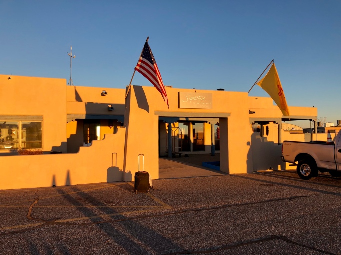
- Signature Flight Support at Santa Fe Airport, NM (KSAF). (Bruce Holmes)
Flight Day 3: Dawn Launch from Santa Fe, Skirting Their Mountains, to Liberal, KS for fuel, then on to Clinton, MO and St. Louis, MO. Happy Thanksgiving!


I left Santa Fe at 0-dark 30 and headed toward Kansas. The orange sky in this sunrise image is a likely a lingering consequence of California wildfires that I witnessed as far east as Kansas City. This is one of my favorite images of the trip.
Flying Eastward from Santa Fe. Orange Smoke at Sunrise from the California Wildfires. (Bruce Holmes)
Sunrise East of Santa Fe, Turning the Corner Toward the Plains of Kansas.
Flying out of the desert to the plains, I saw irrigation crop circles in southwestern Kansas. I have been told that they are visible from space.
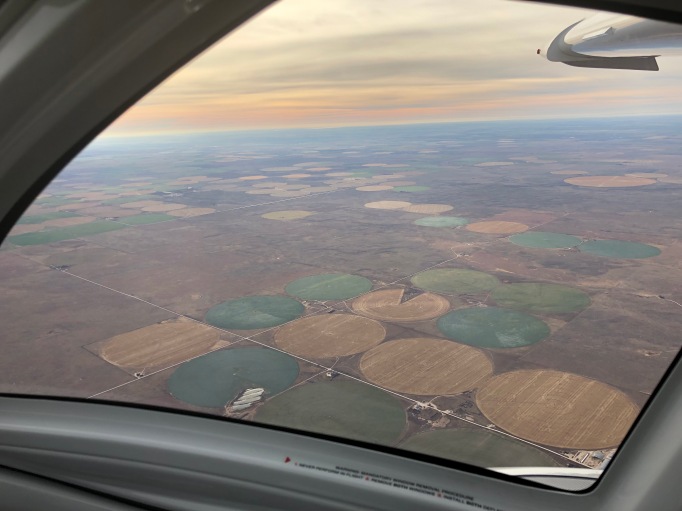
Crop Circles Dotting Southwest Kansas. (Bruce Holmes)
I re-fueled in Liberal. KS, about 70 miles east of the state’s southwestern border. I called the FBO manager the night before about getting gas on Thanksgiving Day. He explained, yes, his kids would be running the desk and gas would be available. Aviation is often a family affair, and this family delivered.

Thankful to Find Gas on Thanksgiving Day. (Bruce Holmes)
After gassing up, I flew over Cheney Reservoir, northwest of Wichita, KS, a temptation for a splash and dash, but not on this mission plan. Eisenhower Airport (KICT) in Wichita. Runway 32, aligned with the view in the bottom image, is the one I flew from on my first solo flight under my father’s watchful instruction. He exited our family airplane, stood in the grass along the runway on January 22, 1966, and witnessed the beginning of my 50+ years of flying.


Across the Kansas Plains from Liberal to Clinton, MO (KGLY), For Self-Fueling.
The left photo below shows the austere exterior of the pilot’s lounge at the unattended airport in Clinton, MO. It was not the least bit austere on the inside with leather seating and a large-screen TV. Pilots like their comforts. At first the self-service fuel pump would not read my credit card (oh-oh!). I re-read the instructions and got it right, then continued on to St. Louis, flying over the Lake of the Ozarks.


Lake of the Ozarks.
The Lake of the Ozarks is one of the largest man-made lakes in the United States and a playground for fishing enthusiasts, boaters, and seaplane pilots. In fact, while most of the state’s large lakes are open to seaplanes, they have some restrictions because they are Corps of Engineers Lakes.. The good news is that the Lake of the Ozarks is the only lake with no restrictions. It merits a return visit.

Lake of the Ozarks, Missouri. Splash In Next Time! (Bruce Holmes)
The Junction of the Osage River Joining the Missouri River
I had been following the contours of the Missouri River. I saw the Osage River to the right below and continued to follow the Missouri River straight ahead. I plan to return in the future, following the trail of the 1804-06 Corps of Discovery Expedition led by Meriwether Lewis and William Clark.
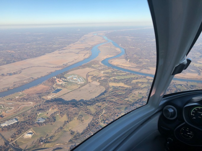
THE Missouri River of Lewis and Clark Fame to the Left and Straight Ahead. (Bruce Holmes)
Because I am flying low over the water, I have limited ability to see the airport in the distance. The tower controller at the Spirit of St. Louis Airport (KSUS) in Chesterfield, MO. offered to help by turning on the approach lights, so I could pick out the runway better from a distance. Bingo, there we are! In reality, the GPS-fed moving map does a great job of providing detailed guidance, but it is nice to have controllers who want to help.
Runway 08R at Spirit of St. Louis Airport (KSUS). (Bruce Holmes)
Arriving at Spirit of St. Louis Airport, Chesterfield, Missouri (KSUS).
This arrival at “Spirit” was at the end of the longest day, 8-plus hours of flying from Santa Fe to St. Louis, MO, about 1/3 of the distance across the U.S. The flight reinforced for me how much the low-workload makes flying the ICON such a low-fatigue experience. Happy Thanksgiving indeed! It was show and tell time to the family and friends at Spirit.
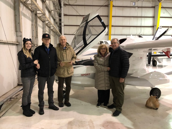
Connie Meets Her New Aircraft with Family Members Enjoying the Fun. (Marlene Waetzig)
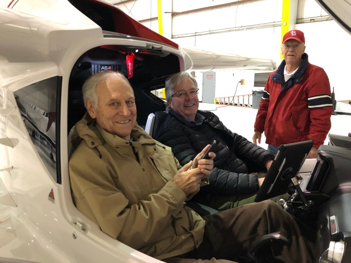
My Brother-In-Law, My First Right-Seater, but Only in the Hangar Unfortunately. (Connie Waetzig Holmes)
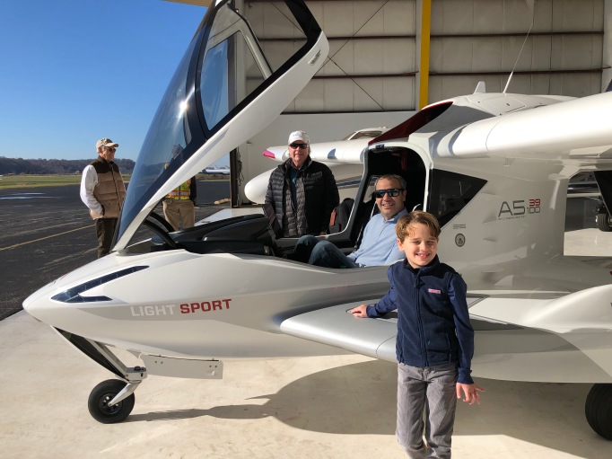
Introducing the ICON A5 to the Next Generation of Potential Pilots. (Connie Waetzig Holmes)
Flight Day 4: St. Louis (KSUS) to Lexington, KY (KLEX) for Fuel and Final Overnight Rest.
Heavy rains in the area grounded me for two nights in Chesterfield, allowing me happily to celebrate Thanksgiving on Thursday and our nephew’s birthday on Friday with Connie and her family. I woke up on Saturday to beautiful blue skies and sparkling sunshine. Connie captured my takeoff from Spirit Airport in an awesome video.
A short 3 1/2 hours later, I landed in Lexington, KY., and spent the night. I do love a good bourbon, but this wasn’t the trip to imbibe. I did, however, put a bottle of Kentucky’s finest in the baggage compartment. Following Kentucky’s Bourbon Trail may have to be on my wish list for future trips.
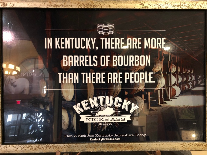
No Problem Finding Great Bourbon to Toast the A5! (Bruce Holmes)
Flight Day 5: Lexington, KY (KLEX) to Chesterfield County Airport (KFCI), VA.
“Did the weather affect your flight?” This is a common question from friends listening to this story. The short answer is, not really, except for a six-hour fog delay in Lexington. I eventually took off and knew I was almost home when I saw the beautiful blue haze blanketing the peaks and ridges of the Blue Ridge Mountains.
The Last Leg from Lexington to Home Over the Blue Ridge Mountains to Virginia. (Bruce Holmes)
My goal was to land in Chesterfield, VA, before sundown. Utilizing the advantage of good tail winds, I landed about five minutes before sundown. I then bedded down the A5 down at Dominion Aviation at Richmond Executive Airport in Chesterfield, MO. Connie, flying Delta from St. Louis to Richmond, picked me up in our SUV, and off we went to the Williamsburg Inn in our hometown to celebrate our 48th wedding anniversary and our ownership of the A5. What a celebratory week!
First Engine Inspection at Dominion Aviation at Richmond Executive Airport (KFCI) in Chesterfield, VA.
Dominion Aviation at Richmond Executive Airport (KFCI) is an authorized ICON A5 maintenance center. The Rotax engine manufacturer (BRP of Wels, Austria), schedules a post-delivery inspection of the engine, including a download from the Flight Data Recorder of all the engine and flight information data from a plug inside the fuselage. The technicians emailed the data file for the hours of flying to the engine company, to ICON, and to me. Good news – No news! In the future, perhaps these data can be sent to the manufacturers over a 4G or 5G LTE air-to-ground advanced connectivity solution for real-time analysis and pilot advisories.


After the inspection was completed, I returned to KFCI and flew the airplane on its first business trip to Raleigh Durham Airport (KRDU) for work with my firm there. (I know, it is not really a transportation machine, but it works!) Finally a few days later, I flew the airplane to its home airport, Williamsburg-Jamestown Airport (KJGG) in Williamsburg, VA.
Since the airplane needs to work for a living, in addition to occasional business travel, I am working with the manufacturer to make the aircraft available for flight training and discovery flights in Virginia and Vermont, as well as in other parts of the eastern seaboard where water-flying has so much appeal.
The Flight By the Numbers
Here is a summary of the big numbers for the whole flight: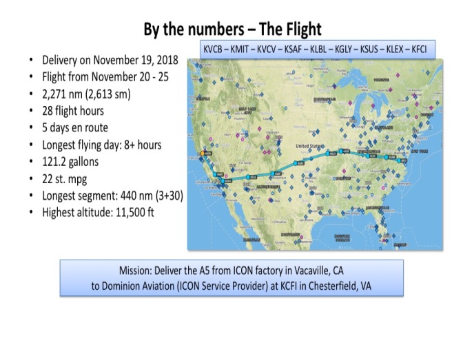 The Aircraft By the Numbers (IconAircraft.com)
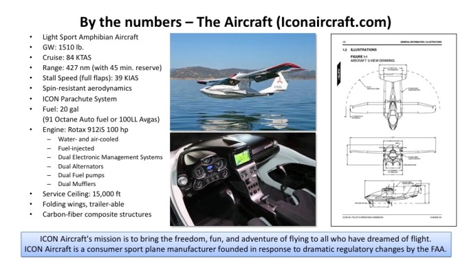
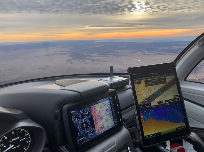
Aviation Aids I Would Not Want to Be Without
I employed the following leading-edge technologies available in aviation today:
- Garmin inReach Mini (TM). The device is a satellite-based position-reporting (over the GEOS system) and text message communication device (over the Iridium Next system).
- Virtual Co-Pilot. My long-time business and aviator colleague, Robert Wright, and I schemed up a trial of a concept for flight operations support (e.g., an “Adventure Concierge”) service using our texting capabilities and daily briefings, covering everything from fuel availability, to crew cars, to lodging, to winds and weather, to sights-to-see along the trip.
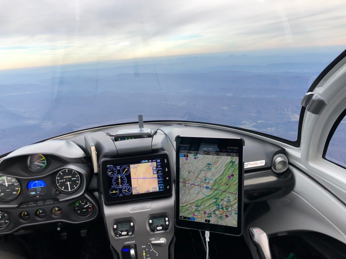
- Garmin GDL-52 Navigator and Aera 796(TM) “Glass” Cockpit Technology. The device integrates with the radio system to make radio management as simple as touch-screen can be.
- iPhone and iPad – goes without saying.
In the not-to-distant future, we can expect to see advances in air-to-ground, air-to-air, and air-to-satellite broadband connectivity solutions that will enable many capabilities impacting efficiency, convenience, and safety for flight deck applications, aircraft systems management, and cabin and passenger services. These capabilities will be enabled through bi-directional, low-latency, low-cost, highly scalable radio systems technologies that are undergoing rapid advancement today. I expect these capabilities will be of increasing value to aircraft small and large, piloted and unmanned, fast and slow, and yes, even amphibians. If you want to know more about what is coming, see SmartSky Networks, LLC.
Why the ICON A5?
As I described in the opening paragraph, the vision of the company’s founders to create new markets for aviation, markets beyond the past aging and mostly male consumer base, was compelling for me. The A5 aircraft embodies both the new market appeal and nearly all of the technologies in which I had a hand in developing over the years. During my NASA career, I was involved in aeronautics research and technology development programs across a spectrum of speeds (subsonic to hypersonic); vehicle sizes (general aviation to large transports); and applications (from personal, to business, to public mobility). The motivation that wove through all of those experiences was an early passion for flying and a maturing understanding of all that flight could mean for society.
Over the decades at NASA, I advocated for the idea that smaller, more advanced aircraft, advanced and simplified airspace management concepts, and community and neighborhood landing facilities would become vital to the mobility of future generations. Today, we stand at the threshold of one of the most significant revolutions in aviation since the jet engine of more than 60 years ago: electrically propelled, clean, safe, and affordable aircraft. Electric aircraft are poised to transform the human experience of flight, the field of aeronautics, personal mobility, and even society itself over time. While the ICON A5 is not powered by electric motors, all of the components of the aircraft — the structures and materials, the digital engine controls, the aerodynamics, and the flight deck systems — were derived from work that I, my NASA colleagues, and our industry and university partners worked on over the years. For me sitting alone in the aircraft, crossing the United States from Vacaville to Virginia, was “living in the message.” Now my ICON goes to work, sharing this message with fellow pilots, students, and the public who would like to learn about the joy of liberty in the air.
Question for Other ICON Owners: What was your experience of flying the ICON A5 from Vacaville to your home?


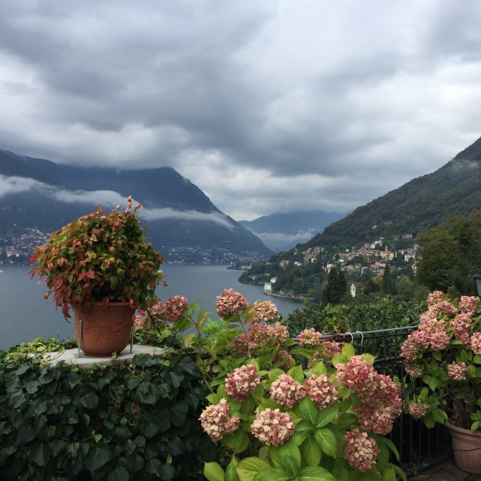 George Clooney of Hollywood fame owns a house across the lake; Tim Cook, the CEO of Apple, is renovating a house under this balcony, and Connie from Topeka, Kansas, is on site and enjoying this view of Lake Como. I am in the playground of the rich and famous, yet I am neither. La Dolce Vita!